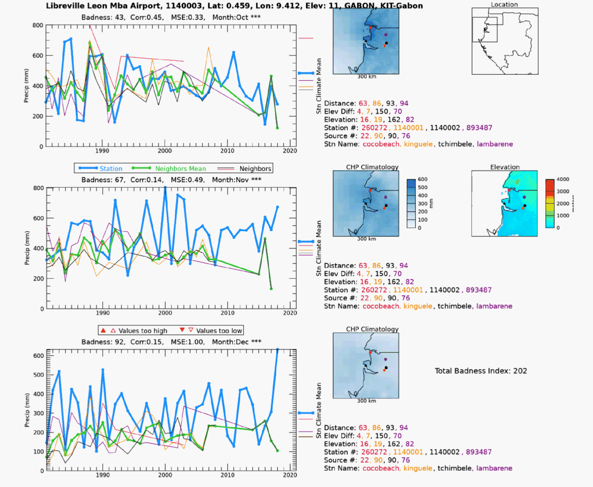
To start with, the algorithm selects a target station from our precipitation database for a given source and searches for neighboring stations within an increasing radius from the station until a minimum number of neighboring stations is found. This number is usually four, but it can be adjusted if stations are sparse in the area of interest. The neighboring stations are selected based on their historical records. For CHIRPS, we are interested in the time period 1981 to present. At each search iteration, if the minimum number of quality stations is not found, the search radius is increased up to a maximum of 150km. If the minimum number of stations is not met at the maximum search radius, then the station is skipped and noted in a log file. When enough quality neighbors are found, the distance weighted mean (DWM) of the neighbors is calculated. Next, the correlation coefficient (R) and the difference between the target station and the DWM are calculated. The difference is then divided by the DWM to express that as a fraction of average error (FAE). These values are used to compute a composite index of the overall "badness" of the station compared to the neighbor's DWM. The badness index (BI) is calculated with:
BI = (1.0 - max(R, 0.0) + min(FAE, 10.0)) * 50.0
The BI is calculated for the 3 wettest months at the station location and added together to produce a "total badness index" (TBI) for each station. The time series of the target station (blue), and its neighbors (distance-weighted line thickness), is plotted along with the DWM (green) for each of the wettest three months. Each of these graphics contains the latitude and longitude, elevation, country name, and source name of the station. The nearby stations’ distances from the compared station, differences in elevation, station, source IDs, and station names are listed to the right of each time series plot in order of distance to the station. These values are color-coded to match the color of the time series plot line. A plot of the locations of each station selected within a 150 km radius is generated and color coded to the upper-right of each time series plot. The target station is plotted in the middle as a triangle, and the neighbors are identified geographically around it. The climatological precipitation value (CHPclim2) for each station is notched along the right side of each plot as a reference to use in determining station validity. The country the station is located in is plotted in the upper right of the graphic, along with its location and the outline of the station location box for reference. Below this is a colorized elevation map of the searched area to help determine if the topography is affecting the station comparisons. In the lower right corner of the plot, the TBI is printed. The names of these graphics files are prepended with the TBI to allow for numerical sorting by the computer’s file system. Typically, only stations with TBI greater than 100 are saved for viewing, since TBI values below that are stations are in very good agreement with their neighbors.
The daily GTS and GSOD values undergo screening to flag potential “false zeros”. These are missing values that have been incorrectly coded as zeros and passed through the automated GSOD and GTS networks. False zeros can produce inaccurate low values in the midst of a rainy season. If a GTS or GSOD station recorded a zero value on a day when the daily CHIRP3 value was above the long-term (1991-2020) average daily rainfall intensity at that pixel, that daily station value is treated as missing instead of zero.
Additional tests are performed at the pentadal and monthly accumulations. If the station reported zero for pentad or monthly values, but CHIRP indicated 7 mm or more for pentadal or 20 mm or more for monthly, the station data is treated as missing.
For each new run of CHIRPS, a number of quality control steps are performed. During this process, maps are made showing the location and number of points excluded due to:
False Zeros: Station reports a zero, but CHIRP > 7mm for a pentad, or 20mm for a month.
Bad Z-score: a Z-score value more extreme than +/- 4.0.
Extreme Values: Station value greater than 2000mm, or greater than 5 times CHIRP (with CHIRP being > 20mm).
The monthly maps can be found here:
In each of these directories, the file names for the products identified are as described below:
Bad Z-score maps are listed as “bad_zscores.YYYY.MM.png”, where YYYY is the 4-digit year, and MM is the 2-digit month. The false zeros product are listed in the appropriate directory as “false_zeros.YYYY.MM.png”, and the extreme values product is identified as “stn.gt.5xchirp.YYYY.MM.png”. These graphics identify the number and location of stations which were flagged by the listed quality control test.
The Reality Checks (R-Checks) process is a hands-on approach that helps produce a quality product for hazards monitoring and other scientific activities. In R-checks, a visual inspection is performed by a team of experts via the Early Warning Explorer and statistically using automated analytics. Ancillary information such as FEWS NET data sets, news reports, and government meteorological reports are frequently used in the process. The R-Checks process has been successful in: 1) Validating anomalous wet and dry events around the world as shown by CHIRPS, 2) catching inaccurate station reports that would have otherwise negatively influenced the data set, such as creating false droughts, 3) checking that the semi-automated flow of CHIRPS data creation is working correctly, 4) identifying weaknesses and strengths of the algorithm and data inputs, which helps in planning improvements for future versions.
As part of this process, a unique collection of images (CHIRPS v3.0 RCHECKS) are made available through the Early Warning EXplorer (
EWX). The RCHECKS images display values of stations on top of the CHIRPS map to identify values that may not align with neighboring stations or the underlying CHIRPS estimates. It can be used to identify false station data, as well as agreement between stations and the CHIRPS fields. Every month before the release of CHIRPS v3.0-final, a team of data analysts quality checks each month’s station-overlay images to identify stations that are suspect or should be eliminated. A report of this R-Checks effort is available on the CHC
Wiki page each month. This report contains information that CHIRPS users may find helpful; for example, users can find notes about major rainfall events shown by the data, and validation for some. Users can utilize the CHC EWX viewer to explore these images combining stations and CHIRPS.
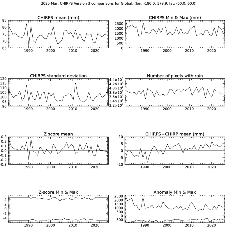
In addition to the station-overlay images, analysts also examine several measures of the new CHIRPS values over the entire time series for consistency. For an individual month, regional and global statistics means are plotted for the CHIRPS values, maximum value, standard deviation, number of pixels with rain, Z-score mean, the difference between CHIRPS and CHIRP, and the Z-score and anomalies minimum and maximums in that region for the current month. A sample graphic is below, and other sample graphics can be found
here.
Due to gaps in geostationary satellite coverage, which varies by region and historical period, the satellite-only precipitation estimate—CHIRP—is sometimes discontinuous. A minimum value threshold is applied to the IR data to identify erroneous data values. In such cases, where there is missing or erroneous infrared (IR) data, CHIRP is filled using unbiased ECMWF Reanalysis v5 (ERA5) precipitation data. This gap-filling is performed at the pentad (5-day) timescale and is also reflected in the corresponding dekad and monthly accumulations. This applies to CHIRP and CHIRPS data from 1981-2022. After 2022, data gaps are not filled. Missing or erroneous IR data from 2023 onward appear as -9999 in both the CHIRP and CHIRPS products. Historically, there are notable gaps in geostationary satellite coverage of certain regions that influence CHIRP, such as large coverage gaps in the early 1980s over Africa and a long coverage gap over part of Central Asia through 1997. Due to CHIRPS being a blend of CHIRP estimates and in situ station observations, the influence of filled data on CHIRPS also varies based on station density (see Global Monthly Station Density). Users engaged in dataset comparisons and trend assessments can learn of which time periods and regions are gap-filled within CHIRP by examining fill mask geotiffs, available for download at several periodicities at the following links, and by visiting the CHC EWX to view these images (at
https://ewx3.chc.ucsb.edu/ewx/index.html, under CHIRP v3.0 and Fill Map layer)
Systematic errors in precipitation measurements often arise from factors such as wind-induced gauge-undercatch, evaporation, and splashing. In CHIRPS v3.0, the Legates-Willmott correction factor is applied to gauge data to account for these errors. Monthly maps of the legates-correction factor can be found in the
CHC data repository and the
EWX.
For every month, we provide GeoTiff files of the number of stations within each pixel for 0.05-degree resolution and 0.25-degree resolution. This product is useful for the identification of station-dense and station-sparse regions of the globe. The GeoTiff files are available for download
here, where you can select the resolution of interest (0.05-degree or 0.25-degree).
Station Density maps are also captured for CHIRPS prelim and final pentads, and can be accessed
here.
In addition to the spatial representation of the global data, we also make available three types of products that capture the station inputs, in different ways.
CHC provides a list of all the stations that make it into the CHIRPS v3.0 preliminary product. It is worth noting that the number of sources of station data going into CHIRPS v3.0 prelim is much more than the two sources used in CHIRPS v2.0 prelim. This significant improvement has helped minimize discrepancies between CHIRPS v3.0 preliminary and final data. The prelim-pentad files can be downloaded
here.
CHC provides a list of all the stations that make it into the CHIRPS v3.0 final product. These files are available
here. In this directory you can find files named “global.stationsUsed.v3.YYYY.MM.csv” which cover the full time series of CHIRPS v3.0. These files are updated monthly after that month’s CHIRPS v3.0 final product is released.
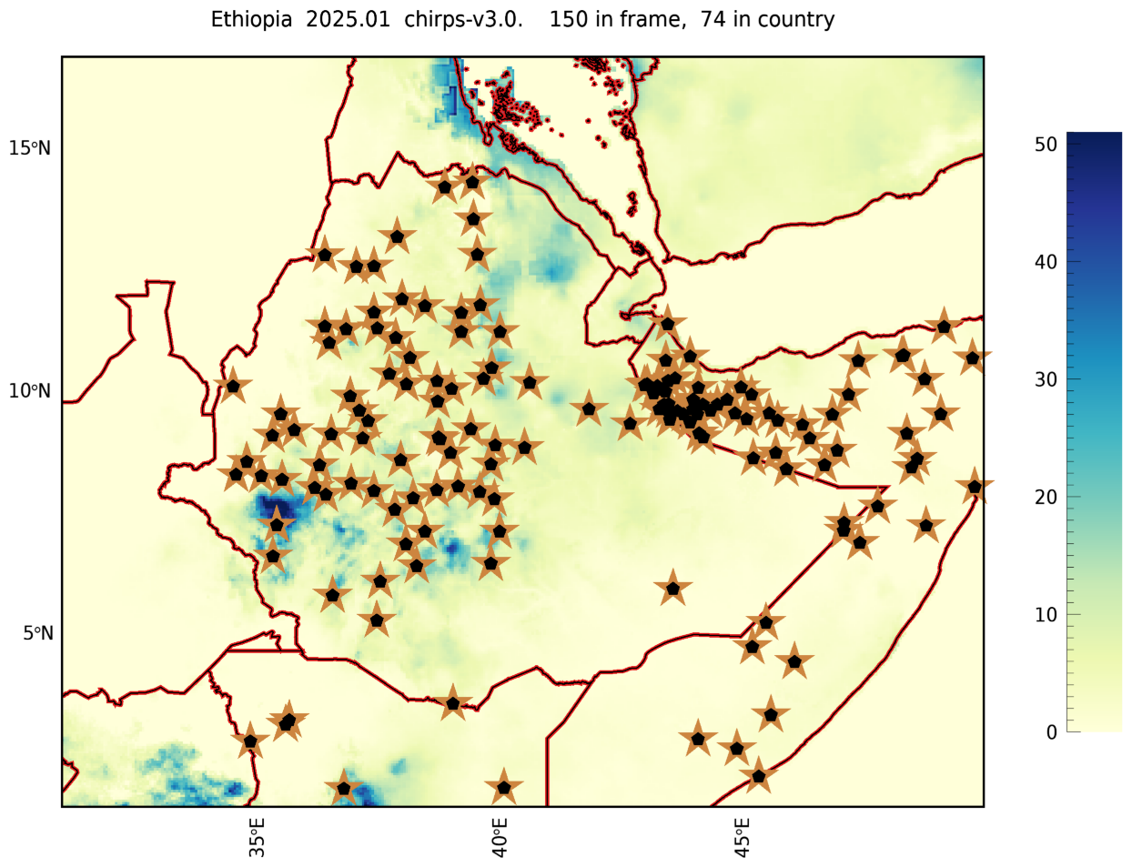
There are two diagnostic products to evaluate stations going into CHIRPS v3.0 for an individual country. The first is a map of the stations' locations falling within a country’s boundaries, as well as neighboring areas, for every month of the historical record. You can find a listing of the mapped countries
here, and then click on the country of interest to find the map for each historical month. At the top of each graphic there is also a count of the number of stations within the country, and in the mapped area (including the country’s surrounding regions) for reference. This is an example of one of the maps, displaying station support for Ethiopia in January 2025.
A second product gives a count of all stations used in CHIRPS in a country. The record covers the full time series of CHIRPSv3.0 from 1981 to present, updated monthly. The plots also compare the number of stations going into CHIRPS v3.0 with that of CHIRPS v2.0. These plots can show the trend in how many stations are reporting over time, and reveal where station support may be increasing or decreasing.
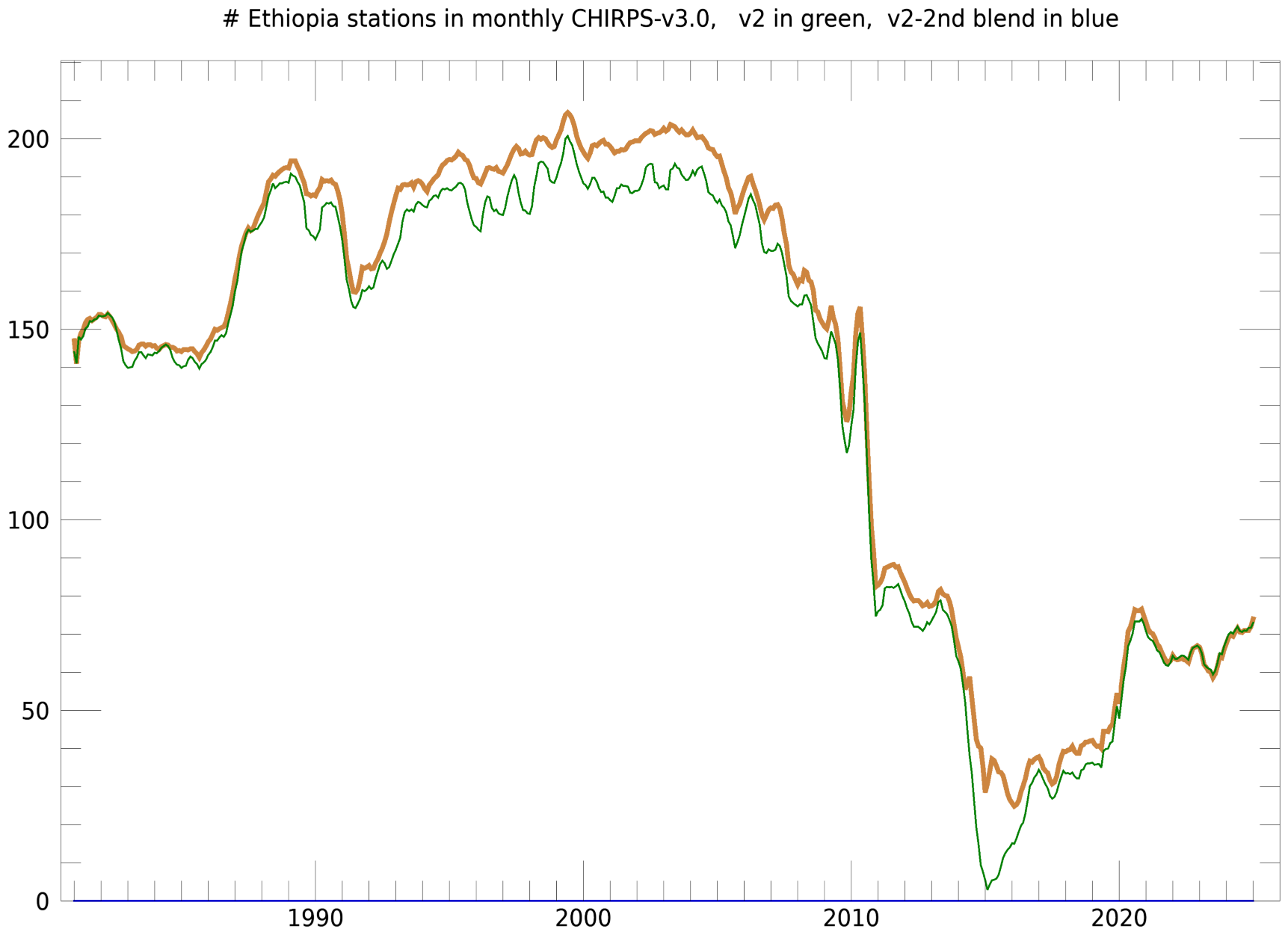
This time series plot shows the changing station support over time, as some sources have decreased coverage while others have come online. Files are available for download here.